by Editor | Mar 2, 2020 | Books, Ecotourism
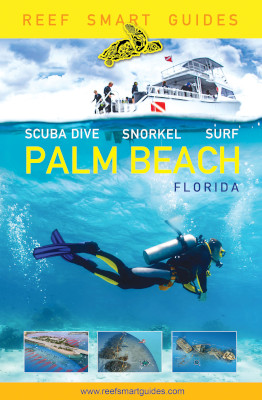
Palm Beach Florida Scuba Dive, Snorkel, Surf (Mango Publishing Group, $34.99) features detailed descriptions, photos and crisp 3D images of waterscapes, including underwater maps and even a ghost ship recreation for a wreck dive description. The 287-page softcover color book by Peter McDougall, Ian Popple and Otto Wagner, part of the Reef Smart Guides series, was published in 2019. The authors are part of the Reef Smart Guides management team.
Why Palm Beach county? “We’re looking for hidden gems and Palm Beach was one of those areas,” Popple, credited in the book for series concept and writing, said by phone from Canada. “Most of the diving you do in Palm Beach County is drift diving.”
The marine biologist explained that the conditions in Palm Beach County required the team to change their techniques. The three men rely on global positioning systems and photogrammetry (using photos to make maps and surveys) to create 3D images. Those images are converted into 2D images in the book. They took a series of photos from which they created a 360 degree view of each underwater area highlighted.
Print books are popular because electronic devices can’t get wet and are easily stolen, he explained. Having a clear idea of snorkel and dive sites ahead of time is helpful because planning is an important element in diving, he added.
Following an introduction to Palm Beach County the book is divided into two main sections Surf breaks and Diving and snorkeling. It also has information on area sea turtles and dozens of fish profiles. The diving and snorkeling section is much longer than the surfing section. The book features detailed information of individual surf, dive and snorkel sites. Each dive site description includes computer generated images, access, reef and wreck details and a rating from one to three for difficulty, current and depth as well as one to three star ratings for reef and fauna.
The Palm beach guidebook contains 46 photos, 15 illustrations, 92 species profiles and 71 3D maps featuring 31 dive and snorkel sites, some of which are sites with multiple wrecks. The Blue Heron Bridge snorkel and dive site featured in the book is “One of the best shore dives in the world,” Popple said.
Reef Smart offers marine and shipwreck guides for divers, surfers and snorkelers. The first Reef Guide book was about Bonaire, “the shore diving capital of the world,” according to Popple. The company also offers services and training to resorts. The authors received support (flights and accommodations) from Discover the Palm Beaches, the county’s tourism promotion entity, and some dive operators.
At our request Popple shared his thoughts on the top three surf, snorkel and dive sites in Palm Beach. For surfing, “Reef Road is the spot that most people both inside and outside of Palm Beach will have heard of,” he said. “It’s by far the best spot in county. It’s a location better suited to more experienced surfers though, especially the adjacent site across the inlet called Pump House, which may only peak on a couple of day of the year, but when it does it’s the place to be.” He also mentioned Lake worth Pier for its consistency and Juno Pier (and the stretch up to Jupiter inlet) for decent breaks when the conditions are right.
For snorkeling: Blue Heron Bridge, Ocean Reef Park and The Lofthus wreck were his picks. About the Blue Heron Bridge he said, “You never know what you’re going to find at this site, anything from seahorses to eagle rays and it’s all located within a protected swimming area.”
“Just off the public beach is a several small patch reefs that support a surprising amount of marine life, including stingrays, small morays and schooling of grunts and snapper,” he said about Ocean Reef Park, adding that there is plenty of parking, a life guard tower, and showers.
About the Lofthus wreck he said, “It’s a hike up the beach, but it’s a fun site to explore and there’s an interesting history to the site (it’s one of Florida’s archaeological preserves) and there’s always the chance of running into something large (e.g. barracuda, nurse shark, sting ray). The downside is that shifting sand bars mean that sometimes large parts of the wreck can be obscured by sediment.”
His top diving picks are: Blue Heron Bridge, The Mitzpah corridor and MV Castor. About the Blue Heron Bridge he said, “This shore dive has to be one of the best in the world and you might be surprised to find it in Palm Beach. It’s a protected area with tons of cryptic species like frogfish, seahorses, and batfish. Because it’s so shallow you can spend a long time underwater exploring the site.”
The Mitzpah corridor is “the mother of all wreck treks,” he said. “Starting at the Ana Ceceilia you can drift for the whole dive from one wreck to the next, a total of five, ranging in size; the largest being the massive Amaryllis, which is 440 feet in length.”
MV Castor “is the wreck that most people want to visit when they dive Palm Beach,” he said. “The ship was a freighter sunk in 2001. The ship has broke into separate bow and stern sections with a debris field of hull plates between. The wreck is famous for it’s giant goliath grouper and during spawning season there can be over 50 present there. You literally never know what you might find when you enter the water here.”
When asked how much influence the tourism authority, hotels and dive operators his team worked with had on the editorial content of the book he replied, “They didn’t. The tourism authority helped facilitate our mapping trip, by organizing flights and places to stay locally, but had no say on the content of the book and neither did the hotels where we stayed. The dive centers advised us on which sites we should map, but again, had no editorial input.”
Palm beach is the team’s fourth guidebook. Next are Grand Cayman in the spring, and the Florida panhandle in the fall; followed by guide books on the sister islands Little Cayman and Cayman Brac, Florida keys, Grenada, and Curaçao.
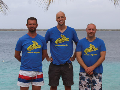
The Reef Smart team
Born and raised in Canada, McDougall received his undergraduate and master’s degrees from McGill University. His focus on behavioral ecology and coral reef ecology led him to two field seasons at Bellairs Research Institute in Barbados, in 1999 and 2002. After graduating in 2003, he moved to the United States and began a career in science communication and writing, publishing in peer-reviewed academic journals and the popular press. He has written on a variety of coastal ecosystem issues, including extensive work surrounding the science of ocean acidification. He is a PADI Rescue Diver with over 300 dives in 19 years of experience.
Popple was born and raised in the United Kingdom, where he earned his undergraduate degree in oceanography from the University of Plymouth in 1994. He worked for five years at Bellairs Research Institute in Barbados, supporting research projects across the region, before completing his master’s in marine biology at McGill University in 2004. He co-founded a marine biology education company, Beautiful Oceans, before founding Reef Smart in 2015 to raise awareness and encourage people to explore the underwater world. He has published in the scientific and mainstream media, including National Geographic, Scuba Diver Magazine and The Globe and Mail. He is a PADI Dive Master with over 3,000 dives in 25 years of diving experience.
Wagner was born and raised in Romania. He graduated from the University of Art and Design in Cluj, Romania in 1991. In 1999, he moved to Canada, where he studied Film Animation at Concordia University in Montreal. In 2006, he turned to underwater cartography and pioneered new techniques in 3D visual mapping. He co-founded Art to Media and began mapping underwater habitats around the world. He received the Prize of Excellence in Design from the Salon International du Design de Montréal. He has also illustrated seven books. Wagner is a PADI Advanced Diver with over 500 dives in 15 years of diving experience.
Photos courtesy Reef Smart

Click to buy Reef Smart Guides Florida: Palm Beach: Scuba Dive. Snorkel. Surf.
by Editor | Dec 2, 2019 | Books, Ecotourism
Complete Guide to Florida Wildflowers*
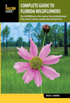
Visitors to Florida have a new tool to identify wildflowers. In the Complete Guide to Florida Wildflowers Over 600 Wildflowers of the Sunshine State including National Parks, Forests, Preserves, and More than 160 State Parks (Falcon Guides, $29.95) Roger L. Hammer, a career naturalist based in Homestead, shared color photos of 686 Florida native wildflowers.
“I chose to omit naturalized exotic species and native woody shrubs and trees, concentrating mostly on herbaceous wildflowers,” Hammer said by email about the photos in the 378-page softcover book published in 2018. “The book took 12 months to complete, but I had a head start by already having published guides that covered central and southern Florida, so I only needed to concentrate on northern Florida and the Panhandle.”
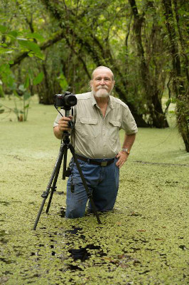
Hammer took all of the photos using a Nikon D810 digital camera with a Nikkor 105 millimeter macro lens. The book is divided into an introduction and six sections. The sections feature flowers by color: blue and purple, pink, red and orange, yellow, brown and green, and white. Each page is dedicated to two flowers. A color photo of the flower occupies the top half followed by the name, description, season when it blooms, where it can be found, and comments.
“The greatest challenge was driving up to the Florida Panhandle about a dozen times from Homestead and back, which takes between 10 and 14 hours one-way, then spending a week up there, driving back home, and then heading back the following month,” Hammer said. “Locating some of the rare wildflowers up there was also challenging, but I relied on botanist friends who live in the Panhandle, and also rangers in some of the state parks.
Roger L. Hammer, author, Complete Guide to Florida Wildflowers
My first love affair with Florida wildflowers was with native orchids, so it was a thrill to photograph species of orchids that I had not seen before. Of the 110 native orchids in Florida, I have now photographed 96 of them. Also, I was able to include all 21 native milkweeds (Asclepias), all 10 native mints in the genus Dicerandra, all 5 milkvines (Matelea), and all 4 species of wakerobins (Trillium). There are many other wildflowers included in this guide that have never appeared in field guides before.”
How can beginners who want to identify a wildflower begin? “Readers should become familiar with botanical names, which they can then use to search the University of South Florida’s Florida Plant Atlas,” he said. “There they will find a range map, common names, botanical synonyms, and a photo gallery. It is one of the more useful websites for Florida’s native and naturalized flora, .florida.plantatlas.usf.edu”

The Butterfly orchid
For orchid lovers the following common species can be seen without too much effort, according to the author. The Tuberous grass-pink orchid (Calopogon tuberosus) can be found in spring in wet, grassy prairies and pine flatwoods throughout mainland Florida. The Butterfly orchid (Encyclia tampensis) flowers in summer and is frequent on trees in upland forests and coastal buttonwood-mangrove forests from north-central Florida south into the Florida Keys. The Spring ladies’-tresses (Spiranthes vernalis) is common along roadsides and in grassy prairies throughout mainland Florida and flowers in spring.
Hammer is a survivalist instructor for the Discovery Channel’s reality TV show Naked and Afraid. He was the manager of the 120-acre Castellow Hammock Nature Center for the Miami-Dade County Parks Department for 30 years. In addition to the new book he is the author of Everglades Wildflowers, Florida Keys Wildflowers, Central Florida Wildflowers, Attracting Hummingbirds and Butterflies in Tropical Florida, Exploring Everglades National Park, and Paddling Everglades and Biscayne National Parks. He lives in Homestead with his wife, Michelle.
*Photos courtesy of Falcon Guides, Paul Marcellini, Roger Hammer
by Editor | Apr 23, 2018 | Books
By Scott S. Smith*
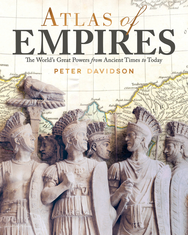
Atlas of Empires
I’ve been hooked on visiting destinations that played some important role in history from the moment I first set foot on foreign soil at 19 in what was then called West Germany (where my jaw stayed dropped for two years just looking at the ancient architecture). I’ve been fortunate in having had a chance to write extensively about the events and leaders of the past, and I’ve learned that there is no book, film, or website that can replace the 3-D experience of being at ground zero of some world-changing moment (usually served by a cutting-edge local museum that can thrive at a place of pilgrimage for history buffs).
That said, Atlas of Empires: The World’s Great Powers from Ancient Times to Today by Peter Davidson (Fox Chapel Publishing, $19.99), a 240-page paperback published in 2018, comes close to being a time machine that immersed me in its pages. When I read history in hard copy, I’m used to having to highlight the text I think I will need when I write (or if it’s an overview covering a topic I think I know, I listen to CDs when on long drives or stuck in traffic, usually from the estimable Teaching Company). I found myself underlining passages on almost every page of Davidson’s tome.
What I don’t tend to do with books is study the graphics, unless they involve battlefield movements. But this Atlas was a revelation of global history for me. Its text and pictures prompted me to make connections between empires and events, reminding me of facts I had forgotten, and enriching my future travels, even illuminating my past trips. Davidson (co-author of Milestones of History and a director of documentaries for the History Channel) wrote a remarkably concise yet thorough summary of the major events of world history, describing how each civilization grew and the causes for its disappearance or its evolution into today’s nations.
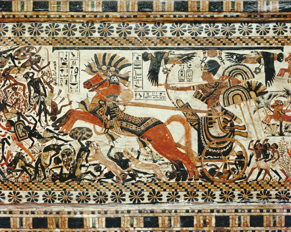
Circa 2005, detail showing the destruction of the black Africans painted on the box of stuccoed wood, from the tomb of the pharaoh Tutankhamun. (Image by ©Robert Harding World Imagery/Corbis)
It’s one thing to recall that Egypt’s Old Kingdom, whose pharaohs built the first pyramids, lasted five centuries, B.C. 2686 to 2181 (BCE for the politically correct). But even though I had made my first book report on Egypt in third grade and had the honor of having the country’s head of antiquities, Zahi Hawas, as our guide through the stunning Cairo Museum, I had forgotten that the Middle and New Kingdoms also lasted a half century each. The thumbnail sketches of the great pharaohs highlight their astonishingly long reigns. For example, Thutmose III, who was constantly on the front lines and expanded the empire to its farthest reaches, died after 54 years on the throne. Rameses II built many of the great monuments during his 67 years in power. Yet Tutankhamun, whose treasures are touring the United States as I write, only lasted nine years as pharaoh.
The chapter on Persia is a reminder of how well some far-flung ancient empires were managed, despite staggering challenges in communications, logistics, and cultural differences. The godfather of the study of modern business management, Peter Drucker, was once asked who the greatest leader in history was. His answer surprised many (and implied it’s been downhill since): Cyrus the Great, who became leader of the Persian tribes in 559 B.C. and died in battle in today’s Kazakhstan in 530. He fostered goodwill and loyalty by promoting religious tolerance and is mentioned 22 times in the Bible, having freed the Jews to return to Israel in 538 after 48 years of captivity in Babylonia (Cyrus is said to be the only gentile who was ever declared a “messiah”). With Iran constantly in the news for the past four decades, it’s helpful to know how it fits into the Persian empire it identifies with. That stretched north to include what is now Uzbekistan (the city of Samarkand is one of the world’s great and largely undiscovered destinations), east to encompass Afghanistan and Pakistan, and west to take in part of modern Greece, Turkey, and Egypt.
The text is full of facts that surprised me: Sparta’s population was 80 percent slaves (compared to Athens’ 30 percent); celibacy was only insisted on for all clergy by the pope in 1074; 240,000 were killed in the final battle for the Aztec capital of Tenochtitlan; the Inca empire, which stretched 3,000 miles, was managed without writing; 20,000 of the African American slaves who fought against the colonists during the American Revolution left with the British afterwards; in 1839, the Chinese dumped 20,000 chests of opium into the sea, which had been delivered by British traders, so the United Kingdom’s government retaliated by sending gunships to annex Hong Kong and open five new ports.
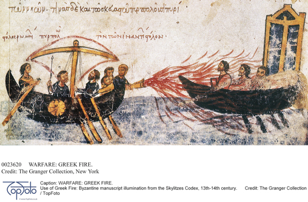
Use of Greek Fire: Byzantine manuscript illumination from the Skylitzes Codex, 13th-14th centuries.
While the book’s art is often eye-catching (such as statues depicting Genghis Kahn’s mounted warriors near Mongolia’s capital of Ulaanbaatar, Byzantine sailors spraying Arab ships with mysterious “liquid fire”), the reason this volume is essential for me as a serious history traveler is the maps. By using different shades to denote where and when empires expanded, even newbies to historical geography can quickly grasp the flow of conquest or assimilation. There are also symbols that show what the most important economic resources were for the region, including slaves, obsidian, and hemp. Gold made Mansa Musa of the Kingdom of Mali in northwest Africa the wealthiest man of all time with $400 billion in today’s money (ruling from 1312 to 1337 A.D. BCE). Davidson is particularly good at working in business history, such as how and where tiny Netherlands created a far-flung commercial empire by taking advantage of new technology and financial systems.
The maps make clear the vast territory that the Mongols conquered (from eastern Europe east, including most of the Middle East, Central Asia, Russia, and China), where precisely the first global empire, Spain’s, was located; and what it meant for the sun to never set over land where the British queen reigned. The maps that break down Chinese history helped me as a non-specialist understand the territory ruled by the dynasties of the Qin, Han, Tang, Song, Yuan, Ming, and Qing, and how they were culturally different (under the Ming, Admiral Zheng’s large fleets sailed as far as Africa. I think Gavin Menzies makes compelling arguments for his foray across the Pacific in 1421: The Year China Discovered America).
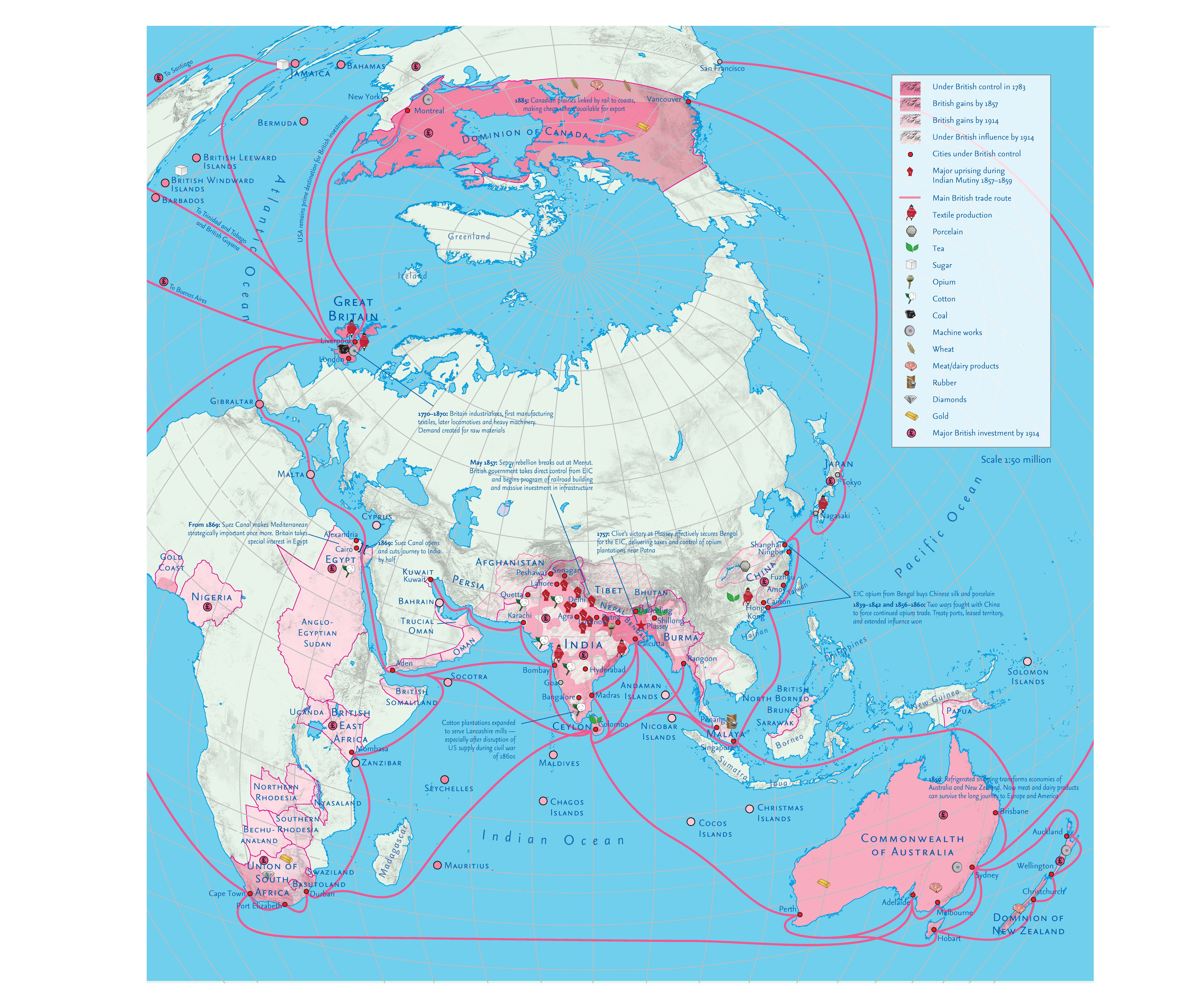
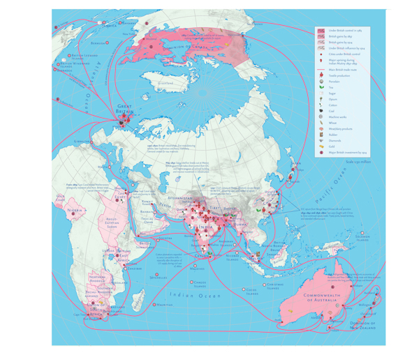 The Second British Empire (click to enlarge)
Also valuable is the recommended list of books for each chapter for readers who would like to know more about the people, stories, and meaning of history without being drowned in the details of scholarship. I plan to give this book the time it deserves by taking it on a trip to read the short chapters and study the maps in spare moments, like waiting in line at the airport. If I wasn’t making historical destinations a priority before, I have a much longer bucket list now that I finished reading it.
*Photos courtesy Fox Chapel Publishing
by Editor | Nov 27, 2017 | Books, Food
By Elena del Valle
Photos by Gary Cox*
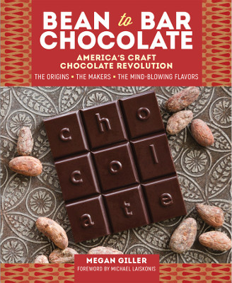
Bean to Bar Chocolate by Megan Giller
I have had chocolate in a number of forms and locations ranging from exotic and improbable such as a safari lodge and mundane such as my kitchen. I have sampled supermarket milk chocolate bars and dark chocolate gourmet bars, foreign and domestic. Over the years my preference has migrated from garden variety milk chocolate to the more flavorful options offered by specialty brands and artisan vendors. For some time I have been a fan of single origin chocolate bars, especially the plain dark chocolate ones layered with flavors.
My most recent chocolate experiences were enhanced manifold by Bean to Bar Chocolate America’s Craft Chocolate Revolution (Storey Publishing, $19.95), a new book by Megan Giller. Thanks to her detailed descriptions, I became much more aware of the diversity of the domestic craft chocolate movement and dozens of bean to bar makers. The 231-page hardcover book published this year features color photos, color illustrations and chocolate recipes.
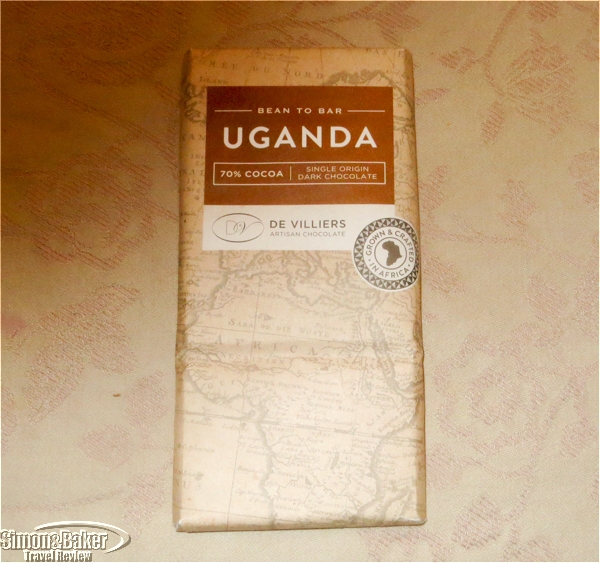
Bean to Bar chocolate from Uganda grown and crafted in Africa
My favorite part of reading her book was the gourmet experiences that followed from preparing her recipe for Water-Based Drinking Chocolate (from Aubrey Lindley, co-owner, Cacao). I also tried the Cocoa Tea (from Miss Choco) made with roasted nibs and water, although that was less to my liking. Once I procured the chocolate bars the Water-Based Drinking Chocolate was a cinch. Like the Cocoa Tea the recipe calls for only two ingredients, chocolate (or roasted nibs) and boiling water.

A few ounces of chocolate melted in a little hot water highlighted the qualities of each type we tasted.
For the Water-Based Drinking Chocolate we sampled four chocolate bar varieties, an organic and sustainably produced bar purchased at the supermarket; a bean to bar 70 percent single origin from Uganda made by De Villiers Artisan Chocolate near Paarl, South Africa; and a half and half blend (all we had available were partial bars) of single origin bean to bar Honduras The Lost City 72 percent and Dominican Republic Duarte 70 percent from Castronovo Chocolate from Stuart, Florida.
The beverage made with the supermarket bar was so awful we threw it out without finishing the serving. The Ugandan beverage tasted better although it was lumpy and had a medium to mild flavor, nothing extraordinary. The texture, even after whipping it twice with a small whisk, was lumpy. In defense of the makers it was past its expiration date. It was a good thing that we first tried the recipe with the Castronovo chocolates because we might not have sampled further otherwise.
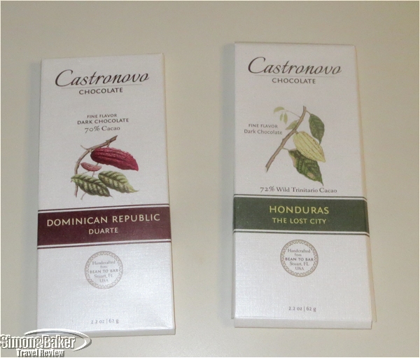
The Castronovo chocolate bars were our favorites for the chocolate beverage.
The Castronovo blend was delightful, dark and rich with a hint of smokiness and flavors that lingered on the palate. Later, I bought more of the Dominican Republic Duarte, my favorite of the two available at the small shop where I purchased them, planning another Water-Based Drinking Chocolate made with those bars. Also, I want to sample more domestic bean to bar chocolates and plan tastings, maybe even try some of the other recipes in the book.

Megan Giller, author, Bean to Bar Chocolate
Giller, a Brooklyn resident, is a food writer, specializing in New York City and Austin, Texas. She writes Chocolate Noise, a blog. Giller’s chocolate knowledge shines throughout the book and her enthusiasm is contagious. She shares information on the craft movement, the people behind the chocolates from the farms to the makers and their approach to purchasing cacao beans, roasting, processing and making mostly single origin chocolate, mainly with only a limited number of ingredients. She also addresses history, equipment, labels, sustainable practices and pricing. There is a list of her favorite bean to bar makers in the back of the book.
*Book photos: Storey Publishing
 Click to buy Bean-to-Bar Chocolate
by Editor | Jun 5, 2017 | Books
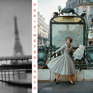
Paris Metro Photo*
For lovers of the Paris metro and transit fans Actes Sud recently published Paris Metro Photo ($55), a 406-page hardcover volume featuring some 250 photos of the heyday of the Paris metro. It has more than a century of photographic documents and photos from Robert Doisneau, Henri Cartier-Bresson, Brassaï, Edouard Boubat, Izis (Israëlis Bidermanas), Francois Kollar, Willy Ronis, Robert Capa, William Klein and Johan Van der Keuken among others.
The book features varied genres and photographic practices, including photojournalism, photo stories, street photography, fashion photography, architectural photography and industrial photography all centered around the history of the development of the Paris metro. In 1900, when the first metro rolled from west to east across Paris, from Porte Maillot to Porte de Vincennes it quickly became a cultural symbol of France, Art Nouveau and urban technological innovation. By then photography had been around for five decades and technological advances had made light cameras possible.
The book is divided into twenty year periods beginning in 1900. Each photo is accompanied by a description and date. The photo sources are public and private such as art galleries, AKG Images, Getty Images, libraries, and museums in France, The Netherlands, Scotland, Switzerland, and the United States. The book was published as a project of the Paris RATP (Régie Autonome des transports Parisiens) public transport authority. In addition to the photos there introductory statements by Anne-Marie Garat and Julien Faure-Conorton (he selected the photography) as well as a brief description for each twenty year section of photography.
*Photo courtesy Actes Sud

Click to buy Paris Metro Photo
by Editor | Jun 20, 2016 | Books
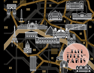
The Tall Trees of Paris*
In The Tall Trees Of Paris (Overcup Press, $49) art enthusiast Matt Wagner showcases 42 contemporary Parisian artists and their work. The 285-page hardcover color book in English and French, released May 2016, took him a year from idea to publication. There was no cost to the artists to be included.
Each artist profile includes a photo of the artist’s work space, a portrait of the artist or the self image of her or his choice, and photos of his or her work. Wagner selected the artists through his contacts in the art world. The handwritten answers to nine identical questions appear on one page and a typewritten translation in English appears on the opposite page. Among the questions are the artist’s favorite restaurant, bars, shops and museums.
“Paris is the foundation of contemporary art, the requirement for graduation,” said Wagner in a press release promoting his new title. “Accordingly, it’s also easily overlooked. Like arches that support an ancient aqueduct, nobody even notices them as long as the water is flowing. But without Paris, the flow of art would have stopped. Paris is good at art. Good enough that people have stopped noticing and just take it for granted. Ultimately, the Tall Trees books are about people. The questionnaires introduce the featured artists to readers, detailing their favorite things about the place they live and work. We become invested in the artist’s wellbeing like that of a friend.”
The artists featured are: 2Shy, Alëxone, Alexandra Arango, Céline Artigau, Nicolas Barrome Forgues, Martes Bathori, Blek Le Rat, Agnes Boulloche, Broll & Prascida, Thierry Bruet, Ludovic Debeurme, Veronique Dorey, Dugudus, Elobo, Christelle Enault, Agnès Ernoult, Sébastien Féraut (Niark1), Christian Guemy (c215), HONET, Kerascoët, Koleo, Koralie, Eric Lacan (Monsieur Qui), Hubert de Lartigue, Jean Leblanc, Jean Lecointre, Lek & Sowat, Levalet, Nicolas Martin, Jean-Michel Ouvry, Tristan Pernet, Aurore Petit, Bruno Pontiroli, Francesca Protopapa (il Pistrice), Sebastien Preschoux, RERO, Jérémy Schneider, Supakitch, Sébastien Touache, TYRSA, Amandine Urruty, and Frédérique Vernillet.

Matt Wagner, editor, The Tall Trees of Paris
”
The Tall Trees of Paris
book is for the curious, the traveler and the art lover,” Wagner said, by email through his publisher, when asked who might like his book. “It’s a great travel guide for finding undiscovered spots in Paris and it’s great for learning more about discovered and undiscovered artists.” As to the criteria he used in selecting the artists for inclusion, he said,”
I am completely selfish in this aspect. I choose artists that I like their work. Lucky for me that my taste is pretty diverse. That diversity comes through in the curation of the book with the selection of painters, installation artists, sculptors, street artists, illustrators, etc.
With the Paris book I mostly found artists through networking. I would meet one artist or another curator and they would recommend an artist. That artist would then recommend another. I was able to build up quite a roster of artists in this manner.”
When asked what was the greatest surprise he had from the book project he said, “My biggest surprise is how hard I fell in love with Paris. I had only been a tourist previous to the book and didn’t really think I would become so enamored with people of Paris.”
Wagner is the founder, owner, and curator of Hellion Gallery in Portland, Oregon. Born, raised and educated in Indiana, after moving west, Wagner fell in love with Portland and learned the ropes at several galleries before opening Hellion in 2010. Prior to the Paris book, he published The Tall Trees of Tokyo (2012) and The Tall Trees of Portland (2014).
*Photos courtesy of Matt Wagner
Click to buy The Tall Trees of Paris


 International")
